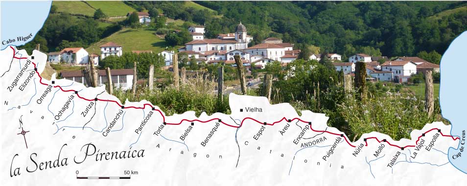


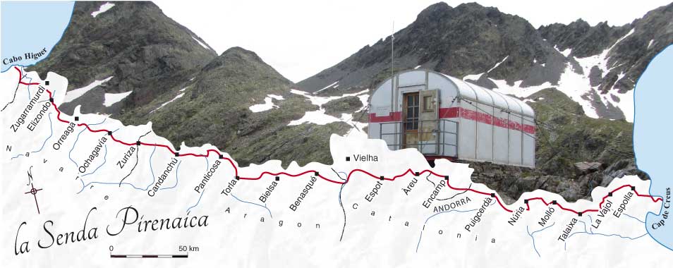


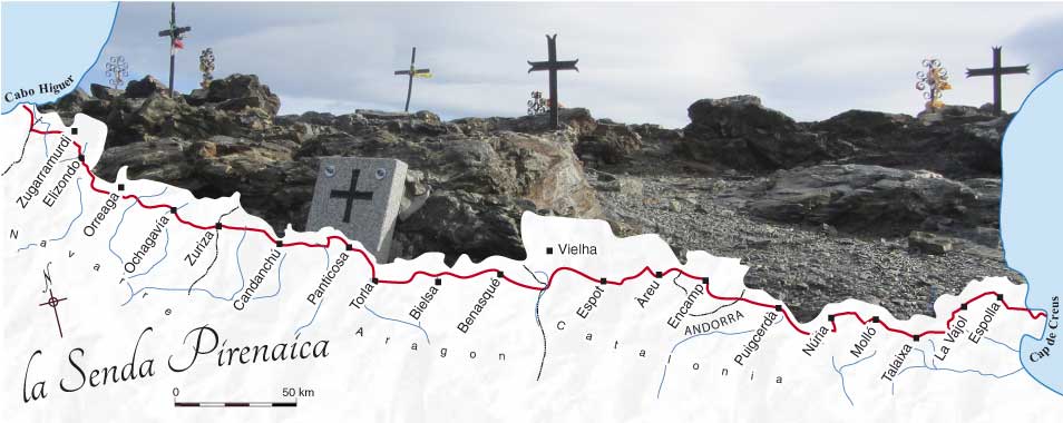
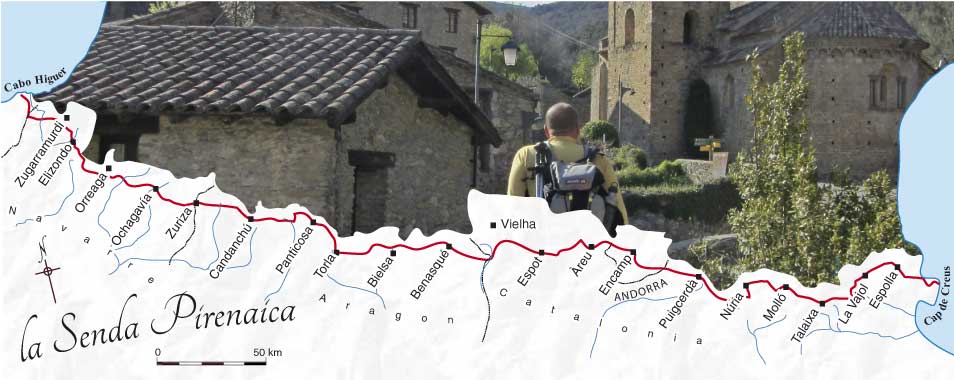
Fourteen routes over the Pyrenees
Before the 1970s only a handful of walkers had crossed the Pyrenees from E–W but hundreds of thousands had done it from N–S or S–N, and not just at the ends near the coast. Hannibal and Pompey; pilgrims on the Way of St James; Cathars; pedlars; shepherds; Napoleon’s armies; smugglers; Ramond, Russell, and other explorers; golondrinas; priests with Spanish religious statues; political refugees; the entire Spanish government with its paintings and gold; Jews and pilots; maquis; economic migrants; terrorists… All crossed the Pyrenees.

- 1. Pilgrims on the Way of St James: Auritz/Burguete
- 2. Golondrinas: Zuriza and Isaba
- 3. Romans, railways, and roads: Candanchú/Canfranc
- 4. Pilgrims, pedlars, smugglers, hunters, explorers: Bujaruelo
- 5. Soldiers and walkers: Benasque
- 6. Airmen and refugees: Guingueta de Àneu
- 7. Refugees and quixotic soldiers: Tavascan
- 8. Cathars: Cabana dels Espaveres
- 9. The Priest and the statue: Núria
- 10. Botanists: Núria
- 11. Shepherds: Ulldeter
- 12. Politicians, paintings, and gold: La Vajol
- 13. Hannibal, Pompey, and refugees: La Jonquera
- 14. Manel the shepherd: Requesens
- 15. List of routes linking Ariège, Andorra and Catalonia

[Note: some of these routes are not particularly recommended for walkers but are included for their historical interest. Each route includes practical information for those who wish to cross from the Senda Pirenaica (GR11) to the Pyrenean Way (GR10).]
Many of these crossings are now celebrated by official treks, mostly created in the last fifteen years, with interpretive panels and museums by way of explanation. These are known as Grand recorridos transfronterizos in Spanish and Sentiers de randonnée transfrontaliers in French.The Aragon government has just launched a project [Spanish text] to develop them.
For the walker wishing to cross the watershed and for anyone interested in the cultural history of the Pyrenees, these treks are a useful shortcut. Although it is true that the recent initiatives focus on a limited number of passes whereas the historical reality was much more diffuse, it is pleasing to see that the paths are being opened up again.

This is a personal selection of those possibilities I know something about, though there are dozens more. Some of the classic crossings are missing from my list (la Ténarèze; the GR-T 24 from Bachimaña to the refuge Wallon-Marcadau for example) but I hope to be able to fill in some of the gaps this summer.
More can be found in Marie Bruneau and Bertrand Genier’s Passages, Les Pyrénées du nord au sud et réciproquement [Passages: the Pyrenees from north to south and back again].
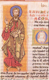
Pilgrims on the Way of St James: Auritz/Burguete

Amongst the many routes over the Pyrenees used by pilgrims over the centuries one stands out: this path between St-Jean-Pied-de-Port in France and Orreaga in Spain which meets up with the Senda a few kilometres further south.
It is frighteningly popular. Official statistics show 59,023 pilgrims passing through Orreaga in 2011 –they have a pilgrim’s passport which is stamped at each stop, so it’s easy to keep count. The pilgrims are easily recognisable by the scallop shell attached to their rucksack.
In the 21st century, ‘pilgrim’ is broadly defined. I once asked a volunteer in a reception centre what he thought.
“I would say that a majority of walkers have some kind of spiritual motive, though not necessarily a Christian one.” He attributed the recent popularity to the designation of the path as a World Heritage Site and the growing number of hostels, making days shorter.
Historically speaking, the path owes its existence to the Codex Calixtinus, written probably in the 1130s to encourage the spread of Christianity in Spain. It is no coincidence that the eponymous St James gained the sobriquet of Matamoros (the Moor slayer).
Intersections: Senda Pirenaica (GR11) – Auritz/Burguete; Pyrenean Way (GR10) – St-Jean-Pied-de-Port
Although vast numbers cross N–S leaving behind them a track which is easy to follow, almost nobody walks the other way. Renowned as the hardest stage on the Way of St James, walkers who have come from the Mediterranean will not be overawed. Heading S–N the crossing from Auritz will take 7 hours; in the other direction 9 hours.
Golondrinas: Zuriza and Isaba

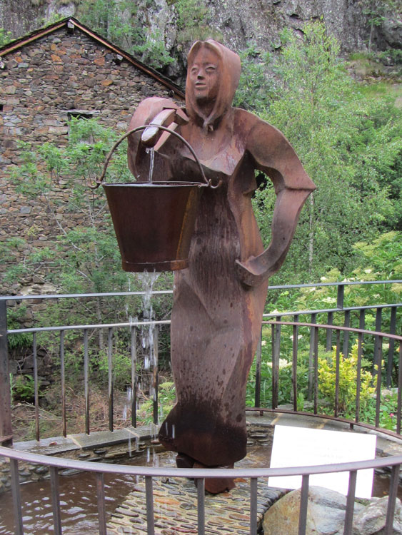
In Spain they were called golondrinas, in France hirondelles. Young women who winged their way across the Pyrenees in search of work when there was little to do on the family farm. Like swallows. Those from the valleys of Salazar, Roncal, and Ansó found themselves work for the winter in the espadrille sandal factories of Mauléon in Frence. Further along the massif the towns provided other temporary nests – for both men and women – and other jobs.
The modern Ruta de las Golondrinas is a fantasy but a nice one nevertheless. Conceived as circular walk, it doesn’t quite reach down to the villages of Ochagavía, Isaba, Roncal, and Anso from where many of the golondrinas originated. But it does provide a framework for linking the GR10 and GR11.

Intersections: Senda Pirenaica (GR11) – Zuriza; Pyrenean Way (GR10) – Lescun
From Zuriza the path follows the rio Veral N to the Refugio de Linza (1h00) (open all year) and then the Camino de France which heads NE. It leaves the Camino to pass over the Col de Pétragéma/Port d’Anso and then heads down the valley of the Gave d’Ansabère to Lescun (8h00).
Intersections: Senda Pirenaica (GR11) – Isaba; Pyrenean Way (GR10) – Arette-la-Pierre-St-Martin or St-Engrâce
It is possible to follow the road from Isaba to the hostel/campsite at Asolaze but perhaps a more interesting option would be to follow the Senda E up through the woods to the pastures of the Belabarze and then join the N-2000 back into the valley of the Belagua (2h30). Afterwards the path heads NE following the road at a distance as far as the Paso de los Vascos then down to Arette-la-Pierre-St-Martin (Refuge Jeandel) (6h00). Another possibility after Asolaze is to head N to St-Engrâce, also on the GR10.
Romans, railways, and roads: Candanchú/Canfranc

Imagine a Parisian mainline station rewritten as a fairy-tale, mysteriously squeezed into a narrow mountain valley. It must be one of the biggest stations in Europe, but instead of serving some metropolis it now serves a village. Instead of the 2000 railway workers initially planned there are just four.
The station is a monument to the failure to create a viable crossing in the central Pyrenees. The first attempt to negotiate Summum Portus (hence Somport) was by the Romans. A thousand years later, pilgrims gave the pass a new lease of life. Then came the railway tunnel and finally, at the beginning of the third millennium, the road tunnel. The road is one of those ideas that looks great on paper, linking Toulouse directly with Madrid, but in practice most of the traffic on the tortuous route goes no further than the foothills.
Intersections: Senda Pirenaica (GR11) – Candanchú; Pyrenean Way (GR10) – Etsaut
Hitch or catch the bus.
Pilgrims, pedlars, smugglers, hunters, explorers… : Bujaruelo
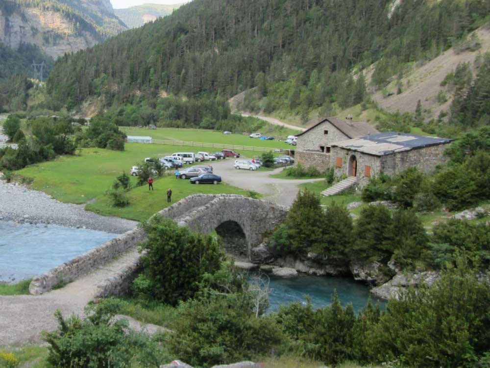
Everybody crossed the Pyrenees here. Everybody, from humble pedlars and shepherds to British squires like the hunter Sir Victor Brooke; not forgetting Count Henry Russell, Ramond de Carbonnières, and Lucien Briet who ‘imagined’ the Pyrenees as we know them, with more than a little help from the locals.

Gavarnie, in France, is much better known than its counterpart, Bujaruelo, in Spain thanks to the cirque. But the refuge de Bujaruelo had already been sheltering travellers for over 500 years before Ramond de Carbonnières stayed here.
There was considerable commotion in the hostel, he wrote. Mule drivers, merchants, smugglers, and customs officers: all going about their business in their own way. Some swearing loudly, others whispering quietly, this one running away, that one robbed, others chasing their prey across the precipices of the Taillon.
The book, published in 1792, brought the mountains to the notice of the world (Paris). So Bujaruelo was one of the midwives present at the ‘birth’ of the Pyrenees. But, in contrast with Gavarnie, the other half of the team, it has remained a modest hamlet.
Intersections: Senda Pirenaica (GR11) – Bujaruelo; Pyrenean Way (GR10) – Gavarnie
The path NE from Bujaruelo (GR-T 39) is well signposted. On the French side with a bit of imagination it is possible to avoid most of the road which leads down to Gavarnie (5h00).
Soldiers and walkers: Puente de San Jaime (Benasque)

Port de Vénasque provides the most beautiful views of Aneto, at 3404m the highest peak of the Pyrenees. And for those who like cross-mountain circuits it is easy to come back by another route.
Like Port de Boucharo between Bujaruelo and Gavarnie, Portillon de Benasque (or Port de Vénasque) has been one of the classic doors through the Pyrenees for many centuries, notably used during the Napoleonic wars.
Intersections: Senda Pirenaica (GR11) – Puente de San Jaime (Benasque); Pyrenean Way (GR10) – Bagnères de Luchon
Follow the GR-T 46 from the Puente de San Jaime along the left bank of the Ésera river to the Hospital de Benasque where it crosses to the right bank. The path follows the valley E and then, starting just above the Parking de la Besurta, climbs to the port (it is advisible to stay in the nearby refugio de la Renclusa overnight to break the journey). The path up to the port is well marked and on the other side there is no possibility of getting lost, as long as you stay in the valley, all the way down to the Hospice de France. Hitch or bus to Bagnères de Luchon (6h30). Alternatively take the bus to Besurta and start from there.
Airmen and refugees: Guingueta de Àneu

Not a serious suggestion for crossing the Pyrenees. Nobody in their right mind would follow this route, unless they had to. And that is the point, the airmen and refugees had no choice. The obvious routes, the low passes were heavily watched. The airmen walked from St Girons in the French Ariège to the relatively accessible Col de la Core (1385m), on under the shadow of Valier to the refuge des Estagnous, and then over the col de Claouère (2500 m) before dropping down to Alos de Izil.
Intersections: Senda Pirenaica (GR11) – Guingueta de Àneu; Pyrenean Way (GR10) – Col de la Core (Esbintz) or Pla de la Lau (La maison du Valier)
The route is described in detail on a site dedicated to the Freedom Path (Chemin de la Liberté). From N to S, it takes three days.
Refugees and quixotic soldiers: Tavascan
This time the refugees were fleeing Franco and heading north. In Tavascan the interpretive panel calls the route the Lakes of Exile but higher up the path joins forces with a circuit called the Mountains of Freedom.
Not many people crossed the frontier here in 1938/9, at least not in comparison with the total of half a million (see la Jonquera, below). Then, after the start of the Second World War the flow reversed with Jews, airmen, and others heading south.
In October 1944 the valley played another minor role, this time involved in the quixotic attempt by a makeshift Republican army to recapture Spain. A small contingent of maquis crossed here in a diversionary tactic while the main force concentrated on the Val de Aran.
Like the Ruta des las Golondrinas, the Mountains of Freedom walk is based on a body of historical fact but dressed up to make it more interesting to modern walkers. The circuit is designed to be started at any point: Graus (3km above Tavascan), Certascan, Aulus, or Ustou.
Also nearby, experienced mountain walkers may like to try the Sky’s Door. La Porta del Cel as it is known in Catalan, it really ought to be called Stairway to Heaven in English.
Intersections: Senda Pirenaica (GR11) – Tavascan; Pyrenean Way (GR10) – Ustou (l’Escolan)
This two-day walk can be split either at the Camping/hostel de Graus or at the Cabane de Marterat just north of the pass. (13h walking in all)
Cathars: Cabana dels Espaveres
This walk evokes the time before the frontiers of France and Spain were even defined, when Cathar dissenters faced with persecution were obliged to cross the mountains to save their necks. The story of the sack of Béziers (1209), where a few dissenters were being hidden by the citizens, is still pertinent today: “Kill them all, God will recognise his own”, the Papal legate is alleged to have said.
Intersections: Senda Pirenaica (GR11) – Cabana dels Espaveres; Pyrenean Way (GR10) – Mérens
Another two-day cross-Pyrenees walk.
The priest and the statue: Núria
Two routes lead from the sanctuary of Núria into France, both ending up at one or other of the railway stations of the Petit Train Jaune (which serves a whole list of trailheads in France).

The statue of Mary and Jesus, the raison d’être of the sanctuary, was spirited across the border by parish priest Mossèn Ventura on 22 July 1936 at the beginning of the Civil War. The anarchists had just taken over in Puigcerdà and burned the church there. Núria must have been next on their list. He took the route over the Coll de Finestrellas to Err; the same pass can be used to reach Lló.
Intersections: Senda Pirenaica (GR11) – Núria; Pyrenean Way (GR10) – Err or Saillagouse for the Petit Train Jaune to La Perxa (Bolquère)
Head NW to the coll de Fenestrellas and then either straight on down to Saillagouse or W into the next valley to Err (9h00).
Botanists: Núria

An alternative route passes by Coll de Eyne and the valley d’Eyne, known for numerous endemics plants.
Intersections: Senda Pirenaica (GR11) – Núria; Pyrenean Way (GR10) – La Perxa (Bolquère)
This easy-to-follow walk heads NNE out of Núria. Well before reaching the head of the valley the path turns W up the steep valley side then N along the ridge to Coll de Núria, also known as Coll d’Eyne. The walk down the valley is very long but beautiful. After Eyne a cross-country path avoids the road to station at la Perxa (8h00). GPS track of Núria to Eyne.
Shepherds: Ulldeter

Not a historic route this – though shepherds must have used it – but a very useful way of crossing over to the refuge du Ras de la Carança at the top of the Gorges de la Carança.
Intersections: Senda Pirenaica (GR11) – Ulldeter; Pyrenean Way (GR10) – Refuge du Ras de la Carança
Via the Col de la Geganta, steep at first but a long cool descent after the pass (5h00).
Politicians, paintings, and gold: La Vajol

Today la Vajol has a population of 86 but during its five minutes of fame it was the capital of Spain. Its art gallery housed many famous paintings and its bank large quantities of gold bullion. This was where the tatters of the Spanish government took shelter at the beginning of February 1939, with the President of the Republic Azaña and the Prime Minister Negrín spending their last night here before going into exile. More significantly, la Vajol was one of the first places where the world woke up to the idea that it has a common heritage and that, particularly in times of war, international efforts might be needed to save it.
As Azaña said to Negrín: “the Prado museum is more important for Spain than the Republic and the monarchy put together”. Starting on 4 February the treasures were packed off to the League of Nations in Geneva. The transfer had only been finalised in the course of the previous evening. It was financed by an unprecedented international consortium: the National Portrait Gallery, the Tate Gallery, the Wallace Collection, the Louvre, the Museum of Art and History of Geneva, the Rijkmuseum of Amsterdam, the Metropolitan Museum of New York, the Royal Museum of Fine Art of Brussels, and the French National Museums. La Vajol was there when World Heritage was being defined.

The village hasn’t forgotten the less illustrious refugees who passed through. The streets of the town are dotted with memorials, including a statue which reproduces a famous photo of refugees crossing the frontier – though it wasn’t here: they crossed the border between Molló and Prats-de-Mollo.

Throughout Franco’s dictatorship such monuments were forbidden and even afterwards the disturbing memories were repressed, partly as a result of the amnesty which eased the transition back to democracy. But now, with the help of the 2007 Ley de la Memoria Histórica (Historical memory law) Spain is finally coming to terms with dark past.
Intersections: Senda Pirenaica (GR11) – La Vajol; Pyrenean Way (GR10) – Las Illas
From la Vajol take the GI-501 north-west, leaving it where it turns NE for a track continuing NW to the col de Lli, after which the path descends to Las Illas (2h00). GPS track. It is possible to return via the Col de Manrella. Description of the route [in French].
Hannibal, Pompey, and refugees: la Jonquera
The Roman general Pompey certainly crossed the Pyrenees at the col de Panissars (he left a monument there to prove it and the wheel ruts of centuries of traffic can still be seen) and it would have been the logical choice for Hannibal on the way to Rome.

Refugees (late January/early February 1939)
In the dying days of the Spanish civil war, after the fall of Barcelona on 26 January 1939 some 250,000 civilians and soldiers fleeing Franco’s advancing troops crossed the frontier between la Jonquera and le Perthus. The French government, having deliberately closed its eyes to the approaching human avalanche, was completely unprepared and corralled the refugees into camps de concentration.
At that time the words didn’t have the negative connotations they have today. But that didn’t make things much better in the makeshift camps set up in the snow on the beach at Argelès. Initially the only shelter was the hollows in the sand which the refugees dug themselves. Driftwood was collected for fires. The principal structure was the barbed wire fence. The principal organisation was the soldiers with guns to keep them there.
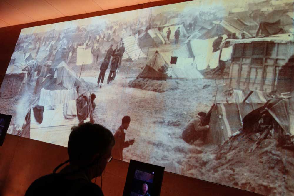
The new Refugee Memorial in Rivesaltes (north of Perpignan) presents a harrowingly comprehensive portrait of the fate of the 1939 refugees (and that of many others in the 20th and 21st centuries) on the site of one of the earliest concentration camps.
Intersections: Senda Pirenaica (GR11) – la Jonquera; Pyrenean Way (GR10) – Col de Panissars
No official path links the two routes here but walkers in la Jonquera can follow the N11 towards le Perthus. After 500m, immediately after the N11 has crossed the motorway take the track to the west leading along the valley of the river Llobregat. After 850m at an intersection head north to the Col de Panissars (1h15).
Manel the shepherd: Requesens
This is not an official trek but deserves a special mention anway. On the French side, walkers will find a 150-year-old sequoia, one of the first to be planted in France after their discovery in America. Manel also left us a series of carved stones, tables, and seats. The works are all the more remarkable as Manel was an illiterate shepherd – his schoolteacher friend drew the letters for him to copy. See also this walk in the Albères which takes in the carvings and the Font (spring) de en Manel.

Intersections: Senda Pirenaica (GR11) – Requesens; Pyrenean Way (GR10) – St Martin de l’Albère
From Requesens follow the higher of the two well-marked tracks heading W (the other is the GR11) up to Coll Forcat. On the other side the path winds about but heads in in the general direction of NE (1h45).
Walking routes linking Ariège, Andorra and Catalonia
The FFRP has just published a guide to cross-border treks starting from Ariège.
- La boucle des Mineurs – Eylie d’en Haut (GR10), Salardù
- La boucle des Passeurs – Aire de la Pucelle, Montgarri
- Autour de Mont Valier – Couflens(GR10), Alòs d’Isil
- Sur les traces de Charlemagne – Rouze (GR10), la Guinguetta d’Àneu (GR11), Tavascan (GR11)
- La boucle des saisonniers – Ustou (GR10), Tavascan (GR11)
- Le tour des 3000 – Marc (GR10), Valferrera (GR11)
- La boucle des trois nations – Marc (GR10), Valferrera (GR11)
- La boucle des Lacs – Refuge du Rulhe (GR10), Col de Puymorens
")